40 Cities OSMnx/Networkx Dijkstra Adjacency Matrices for Traffic Prediction Graph Convolutional Networks
Adjacency matrices were calculated for 40 cities using sensor data from https://doi.org/10.1038/s41598-019-51539-5 (ETH Zürich). I personally rented a Google Cloud server for roughly 500€ to compute these matrices because we have so few of them in the traffic prediction Data Science community. Since most models in the community are being trained on just these few datasets there's risk for overfitting.
Use remove_missing_sensors.py to remove sensors that aren't in both the matrix and data.

Loder, A., L. Ambühl, M. Menendez and K.W. Axhausen (2019) Understanding traffic capacity of urban networks, Scientific Reports, 9 (1) 16283. https://doi.org/10.1038/s41598-019-51539-5
OpenStreetMap https://www.openstreetmap.org/ must also be referenced because the matrices where calculated using OpenStreetMap. If you use any of the Maps you must reference both OpenStreetMap and Mapbox https://www.mapbox.com/ in addition to UTD19.
Furthermore it's probably best practice to also reference cities in publications. Additional data can often be received upon opendata requests from cities.
The code for mapping and calculating the matrices on the other hand is MIT licence.
Tutorials for the code have been provided on Medium by Thomas A. Fink.
Creating an Adjacency Matrix Using the Dijkstra Algorithm for Graph Convolutional Networks GCNs https://thomasafink.medium.com/creating-an-adjacency-matrix-using-the-dijkstra-algorithm-for-graph-convolutional-networks-gcns-cc84c37e297 https://github.com/ThomasAFink/osmnx_adjacency_matrix_for_graph_convolutional_networks
Plotting the Optimal Route for Data Scientists in Python using the Dijkstra Algorithm https://thomasafink.medium.com/plotting-the-optimal-route-for-data-scientists-in-python-using-the-dijkstra-algorithm-14e3e9383a0a https://github.com/ThomasAFink/optimal_path_dijkstra_for_data_science
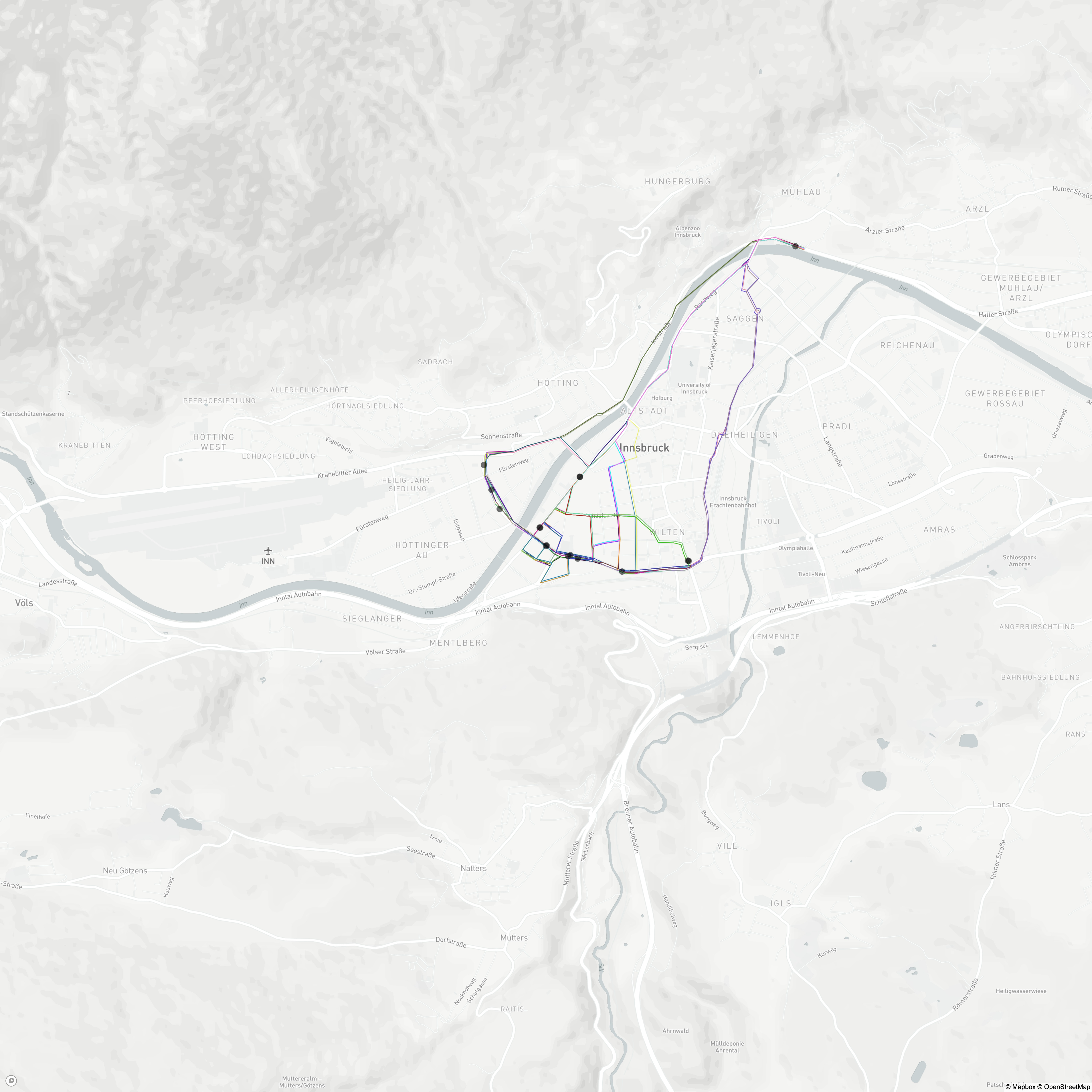
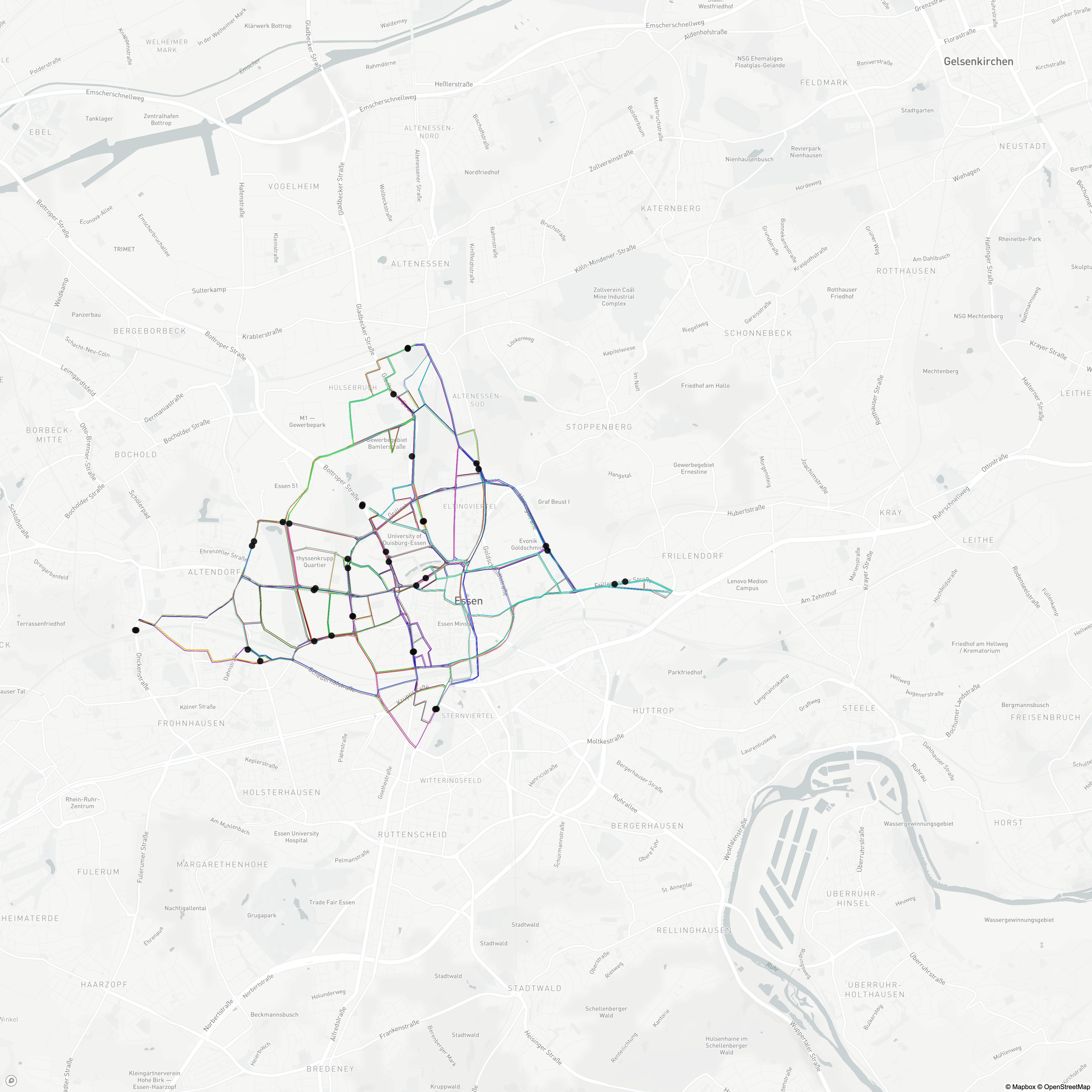
The optimal Dijkstra distances between each sensor with every other sensor was calculated using OSMnx and NetworkX. Each city includes atleast one normalized and one original matrice with the raw values. Two example Graph Networks visualized:
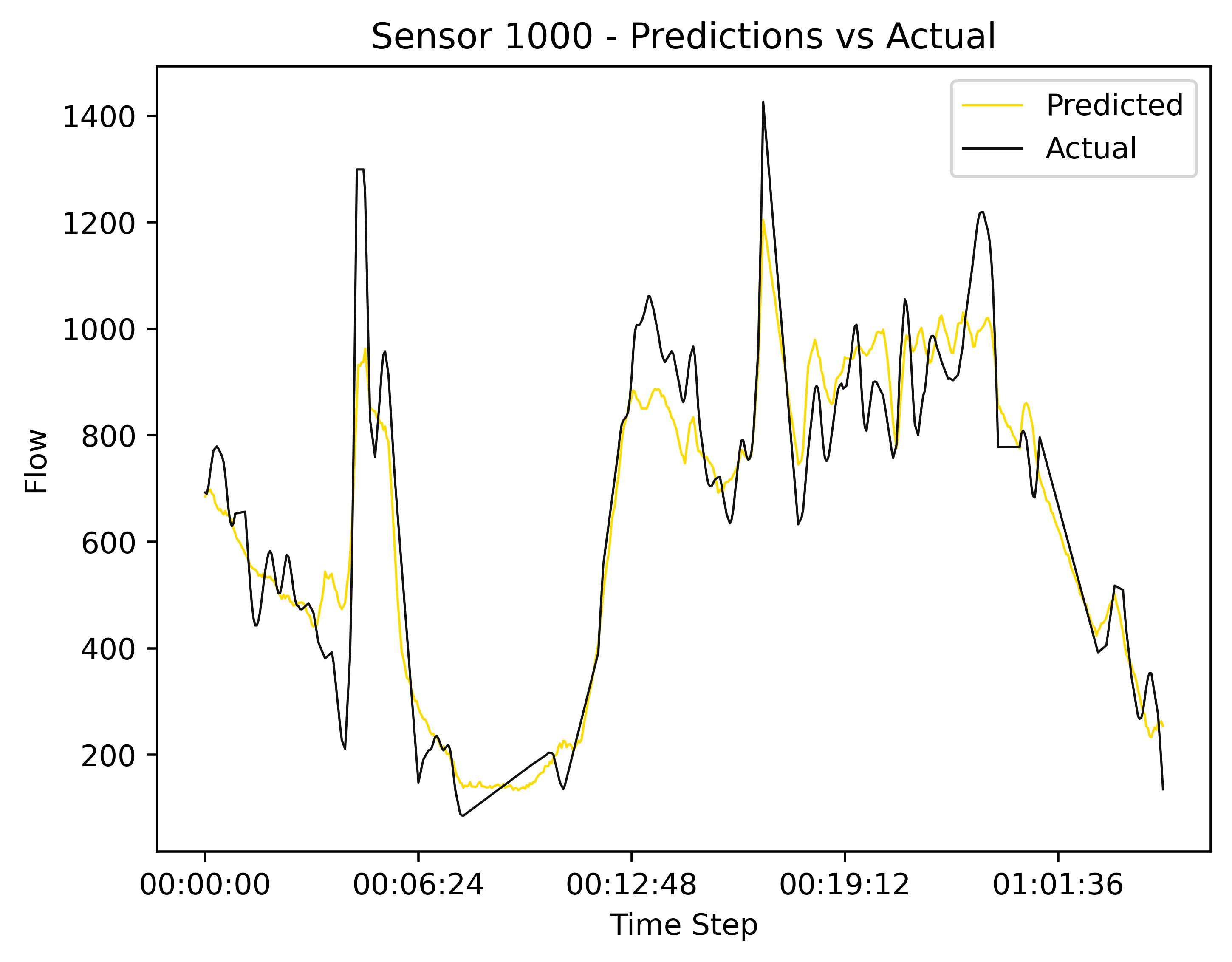
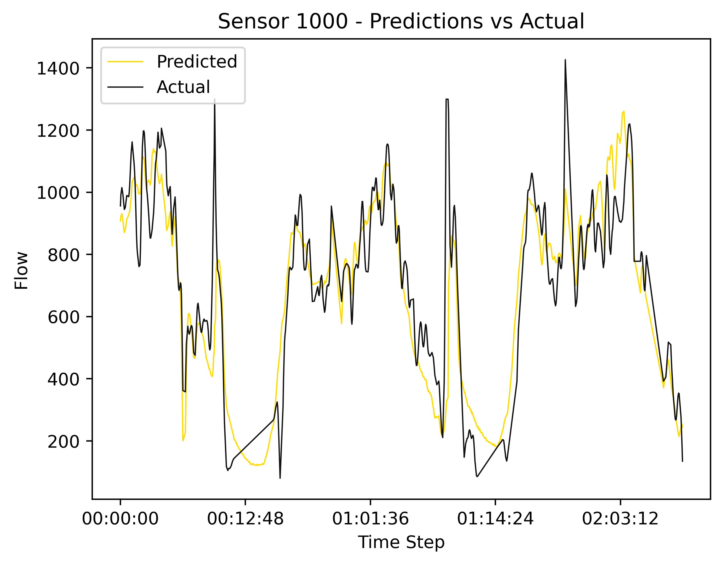
The data can be used for machine learning, but not all cities have enough data. Variables include speed flow and occupancy. I have only tested the Los Angeles dataset with an LSTM-GCN model so far. Accuracy, R2 and Variance were over 90% on par with other datasets such as METR-LA and PEMS-BAY.
Source: https://github.com/graphhopper/open-traffic-collection
https://wiki.openstreetmap.org/wiki/TMC#Available_datasets https://unece.org/transport/transport-statistics/traffic-census-2020 https://telraam.net/#9/48.1497/11.5850 https://www.graphhopper.com/open-source/
https://data-exchange.vicroads.vic.gov.au/ https://data-exchange.vicroads.vic.gov.au/docs/services https://data-exchange.vicroads.vic.gov.au/data-exchange-platform-goes-live
British Columbia https://www.th.gov.bc.ca/trafficData/
https://data.europa.eu/data/datasets?locale=en&query=traffic&page=1 https://www.datex2.eu/
https://contentportal.asfinag.at/data
https://datastore.brussels/web/- https://www.verkeerscentrum.be/uitwisseling/datex2full-
http://www.gencat.cat/transit/opendata/incidenciesGML.xml
https://registr.dopravniinfo.cz/en/
https://tarktee.mnt.ee/#/en/datex
https://www.digitraffic.fi/en/road-traffic/ https://aineistot.vayla.fi/roadworks/roadworks_d2.xml https://aineistot.vayla.fi/roadworks/roadworks_infoxml.xml https://aineistot.vayla.fi/painorajoitukset/painorajoitukset_d2.xml
https://data.nasdaq.com/data/INSEE-national-institute-of-statistics-and-economic-studies-france https://opendata.paris.fr/explore/dataset/comptages-routiers-permanents/information/?disjunctive.libelle&disjunctive.etat_trafic&disjunctive.libelle_nd_amont&disjunctive.libelle_nd_aval
https://opendata.muenchen.de/dataset?tags=Fahrrad https://www.offenedaten-koeln.de/search/type/dataset https://opendata.duesseldorf.de/dataset/verkehrsmeldungen-mobilit%C3%A4tsdaten https://opendata.jena.de/group/mobilitat https://darmstadt.ui-traffic.de/faces/TrafficData.xhtml https://suche.transparenz.hamburg.de/dataset/geo-online-portal-hamburg https://geodienste.hamburg.de/HH_WFS_Verkehr_opendata?REQUEST=GetCapabilities&SERVICE=WFS https://open.nrw/dataset/verkehrszentrale-verkehrsinformationen-der-viz-nrw-fuer-nordrhein-westfalen-1476687235163 https://open.nrw/dataset/verkehrszentrale-verkehrslage-los-1476688071631 https://www.mcloud.de/web/guest/suche/-/results/detail/verkehrsdatenautomatischedauerzhlstellen https://www.bast.de/DE/Verkehrstechnik/Fachthemen/v2-verkehrszaehlung/Daten/2017_1/Jawe2017.html?nn=1819490 https://mobilithek.info/ https://www.mdm-portal.de/migration/ https://autobahn.api.bund.dev/ https://www.mdm-portal.de/
https://github.com/noi-techpark/BZtraffic
http://restrictions.eismoinfo.lt/ https://eismoinfo.lt/#!/
https://www.cita.lu/info_trafic/datex/situationrecord
http://opendata.ndw.nu/ https://gitlab.com/traffxml/vild2ltef
https://gitlab.com/traffxml/traff-gddkia https://kpd.gddkia.gov.pl/index.php/en/homepage/
https://www.promet.si/en/plugins-for-developers
https://statistik.tkgbg.se// https://www.trafikverket.se/tjanster/Oppna_data/oppna-data-vi-erbjuder/
https://www.astra.admin.ch/astra/de/home/dokumentation/daten-informationsprodukte/verkehrsdaten.html
https://www.trafficengland.com/services-info https://www.traffic.gov.scot/datex/ https://www.gov.uk/traffic-counts https://www.data.gov.uk/dataset/dc18f7d5-2669-490f-b2b5-77f27ec133ad/highways-agency-network-journey-time-and-traffic-flow-data
Several entries are take from this stackexchange answer
- nationwide
- Alabama
- Arizona
- Arlington
- California and https://koordinates.com/layer/109326-california-traffic-volumes-aadt/
- Chicago or one specific set
- Colorado
- Delaware Valley
- Florida
- Indiana
- Maine
- Massachusetts
- Michigan (seems to be no longer available)
- Minnesota
- New York City and New York
- North Carolina
- Ohio
- Oregon
- South Carolina
- Tennessee (seems to be no longer available)
- Washington
- Wisconsin
New York City: https://www.nyc.gov/site/tlc/about/tlc-trip-record-data.page
New York City Bike: https://citibikenyc.com/system-data