
This Kit provides an end to end simulation solution for MAV visual SLAM (or path planning) researches.
In this work, several features are added to the default PX4 Gazebo Simulator:
-A realsense D435 model (based on realsense_gazebo_plugin)
-Modified IRIS MAV model
-Several structured/unstructured simulation world
The work has been verified on Ubuntu 18.04/20.04 + ROS melodic/noetic environment
Also, if you want to save time,
we strongly suggest you to use docker image!
The link is right here.
| manual control | Click and fly navigation |
|---|---|
 |
 |
If you still insist not to use docker, here is the installation instructions:
Install pre-requisites (ubuntu 18.04):
sudo apt-get install ros-melodic-mavros ros-melodic-mavros-extras ros-melodic-mavros-msgs libncurses5-dev python3-pip libgstreamer1.0-dev python-jinja2 python-pip python-testresources libignition-math2 libgazebo9-dev
pip3 install --user empy toml numpy packaging jinja2
pip install numpy toml empy packaging
sudo apt upgrade libignition-math2
wget https://raw.githubusercontent.com/mavlink/mavros/master/mavros/scripts/install_geographiclib_datasets.sh
sudo bash ./install_geographiclib_datasets.sh
Install pre-requisites (ubuntu 20.04):
sudo apt-get install ros-noetic-mavros ros-noetic-mavros-extras ros-noetic-mavros-msgs libncurses5-dev python3-pip libgstreamer1.0-dev python-jinja2 python3-pip python3-testresources libignition-math4 libgazebo11-dev
pip3 install --user empy toml numpy packaging jinja2
pip3 install numpy toml empy packaging
sudo apt upgrade libignition-math4
wget https://raw.githubusercontent.com/mavlink/mavros/master/mavros/scripts/install_geographiclib_datasets.sh
sudo bash ./install_geographiclib_datasets.sh
# neglect all gazebo9-related warning
Download and install the PX4 (1.11.0)
git clone https://github.com/PX4/PX4-Autopilot.git
cd PX4-Autopilot/
git checkout 71db090
git submodule sync --recursive
git submodule update --init --recursive
bash ./Tools/setup/ubuntu.sh
sudo apt upgrade libignition-math2 #(libignition-math4 for noetic)
make px4_sitl_default gazebo
Clone this repository to catkin src folder say: ~/catkin_ws/src
cd ~/catkin_ws/src
git clone https://github.com/HKPolyU-UAV/E2ES.git
Install 3rd Part Library
cd ~/catkin_ws/src/e2es/3rdPartLib
sudo ./install3rdPartLib.sh
sudo ln -s /usr/include/eigen3/Eigen /usr/include/Eigen # your Sophus was installed with ros-noetic-sophus (not source)
Compile
cd ~/catkin_ws/
catkin_make
By default ROS_WORK_SPACE_PATH is ~/catkin_ws and PX4_Firmware_PATH is ~/PX4-Autopilot
If Not, Edit the path in E2ES/sim.sh script(Line 1 to 4)
export GAZEBO_RESOURCE_PATH=$GAZEBO_RESOURCE_PATH:~/catkin_ws/src/e2es/gazebo
export GAZEBO_MODEL_PATH=$GAZEBO_MODEL_PATH:~/catkin_ws/src/e2es/gazebo/models
export GAZEBO_PLUGIN_PATH=$GAZEBO_PLUGIN_PATH:~/catkin_ws/devel/lib
cd ~/PX4-Autopilot
to
export GAZEBO_RESOURCE_PATH=$GAZEBO_RESOURCE_PATH:ROS_WORK_SPACE_PATH/src/e2es/gazebo
export GAZEBO_MODEL_PATH=$GAZEBO_MODEL_PATH:ROS_WORK_SPACE_PATH/src/e2es/gazebo/models
export GAZEBO_PLUGIN_PATH=$GAZEBO_PLUGIN_PATH:ROS_WORK_SPACE_PATH/devel/lib
cd PX4_Firmware_PATH
Run the simulator
roscd e2es
./sim.sh
Using keyboard to control the MAV in simulator
roslaunch e2es keyboard_ctr.launch

You can use the FLVIS + MLMapping kit combination to run SLAM. Please refer to the respective repo, FLVIS & MLMap to build them. Also make sure that you safisfy their prerequisites.
The launch file for E2ES are here_FLVIS & here_MAP. Hence, do
roslaunch flvis e2es.launch # for VIO
roslaunch mlmapping mlmapping_e2es.launch # for Mapping
The topics there you might be interested are as follows:
| Topic | Topic Type | Topic Name | Hz |
|---|---|---|---|
| Pose (GT) | geometry_msgs/PoseStamped | /gt_iris_base_link_imu | 50 |
| Pose (VIO) | geometry_msgs/PoseStamped | /mavros/vision_pose/pose | 200 |
| Odom (VIO) | nav_msgs/Odometry | /imu_odom | 200 |
| IMU (PX4) | sensor_msgs/IMU | /mavros/imu/data | 50 |
| IMU (Gazebo) | sensor_msgs/IMU | /iris/imu/data | 200 |
| RAW PCL | sensor_msgs/Image | /camera/depth_aligned_to_color_and_infra1/image_raw | 30 |
| MAP | sensor_msgs/PointCloud2 | /global_map | 20 |
You can modify the launch file, and
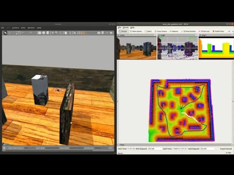
You can use the FLVIS-glmapping-FUXI(localization-mapping-planning kits) navigation system.
The first step is to install FLVIS, glmapping and FUXI accordinly.
Then start the simulator localization mapping and planning kit in sequence.
roscd e2es
./sim.sh

# flvis
roslaunch flvis e2es.launch # under flvis package

# fuxi
## please refer to fuxi repo
This work are based on PX4 Projcet and realsense_gazebo_plugin
Patrick Lo, AIRo-Lab, RCUAS, PolyU
Shengyang Chen, Dept.ME, PolyU