Releases: pysal/pysal
PySAL 2.0.0rc3
Release Notes for PySAL2.0rc3
This is the third release candidate for PySAL 2.0.
Overall, there were 1636 commits that closed 368 issues, together with 236 pull requests since our last release on 2017-11-03.
Changes by package
libpysal:
- weights.distance.KNN.from_dataframe ignoring radius (#116)
- Always make spherical KDTrees if radius is passed (#117)
- [ENH] should
weights.util.get_ids()also accept a geodataframe? (#97) - enh: add doctests to travis (#2) (#112)
- sphinx docs need updating (#49)
- Add notebooks for subpackage contract (#108)
- Api docs complete (#110)
- Doctests and start of documentation for libpysal (#109)
- Add dependencies to requirements_plus.txt for test_db (#107)
- Weights/util/get ids gdf (#101)
- missing adjustments to lower case module names (#106)
- Rel.4.0.0 (#105)
- REL: 3.0.8 (#104)
- error importing v3.0.7 (#100)
- Lower case module names (#98)
- remove function regime_weights (#96)
- depreciating regime_weights in the new release? (#94)
- inconsistency in api? (#93)
- Ensure consistency in
from .module import *in components of libpysal (#95) - [WIP] cleanup (#88)
- docstrings for attributes are defined in properties (#87)
- docstrings in W class need editing (#64)
- version name as version (#92)
- remove
delstatements and modify alphashape all (#89) - libpysal/libpysal/cg/init.py not importing
rtree(#90) - including rtree in imports (#91)
- BUG: test_weights_IO.py is using pysal and hard-coded paths (#85)
- fix hardcoded swm test (#86)
- check for spatial index if nonplanar neighbors (#84)
- nonplanar_neighbors fails when sindex is not constructed. (#63)
- increment version number and add bugfixes, api changes (#79)
- Spherebug (#82)
- only warn once for islands/disconnected components (#83)
- only warn on disconnected components if there are no islands (#81)
- LEP: Stuff/use pysal/network stuff to provide queen weights on linestring dataframes (#59)
- swm fix not ported forward from pysal. (#66)
- import scipy syntax typo in the new issue template (#68)
- deletion of extra spaces in warning message (#78)
- Nightli.es build permissions (#77)
- name of geometry column is hardcoded in nonplanar_neighbors (#75)
- changed geometry column name from a str to an attribute (#76)
- Missing example file (#71)
- if numba isn't present, libpysal warns every time imported (#73)
- add check for disconnected components (#65)
- clean up for release (#74)
- update for new examples (#72)
- Swm (#70)
- Remaining concerns left unfixed in #61 (#62)
- [WIP] Alpha shapes (2D) code (#58)
- [WIP]: add linestring/multilinestring functionality (#61)
- Fuzzy contiguity (#57)
- add berlin example (#56)
- force UTF8 encoding for the long description read (#55)
- add guerry example dataset (#45)
- update georgia shapefile (#53)
- fix typo add
non_planar_joinsinstead ofnon_planar_neighborattr… (#54) - add voronoi to the API (#46)
- ENH: Neighbor detection for nonplanar enforced polygon collections. (#51)
- Missing example used by gwr tests (#43)
- Wplot (#50)
- close the door on 2 for libpysal (#44)
- To networkx argument name changed (#40)
- bump micro version (#42)
- fix networkx adapters (#41)
- minor version bump for release (#39)
- Plot weights (#38)
- forward port of legacy fix #1028 (#37)
- Adding Voronoi generator for cg as well as Voronoi weights from 2-d points (#36)
- bump version for release (#34)
- attach_islands correction: incorporate pr #32 (#33)
- change data type of contiguity W.neighbors value from set to list (consistent with other weights) (#32)
- add a function to attach the nearest neighbor to island (#30)
- fix id2i lookup for string names and make better names (#31)
- two modules “Wsets.py” and "util.py" depend on each other (#26)
- add unittest for Wset.w_clip (#29)
- resolve circular import in Wsets and util (#28)
- update doctests in weights module to use libpysal instead of pysal (#27)
- bump stable date (#25)
- bump version for point release of lag cat fix (#24)
esda:
- enh: updating travis build and rtd (#40)
- BUG: missing rtd file (#39)
- REL: 2.0.1 (#38)
- Prepping for a doc release (#37)
- docstrings are using pysal legacy (#4)
- add zenodo doi badge (#36)
- REL: 2.0.0 (#34)
- Changing esda setup to handle version programatically (#33)
- port legacy esda fix for 1013 (#12)
- notebook links broken (#29)
- include /tests in release (#32)
- Add tests to release (#27)
- Accounting for incoming API changes to
libpysaland adding testing againstlibpysal's master branch (#26) - no
varnamesinMoran_BV_matrix(#22) - add
.varnamesattribute toMoran_BVobjects inMoran_BV_Matrixresults (#23) - Inconsistent metadata in setup.py (#28)
- Update license (#30)
- esda has no readme (#14)
- Readme added (#25)
- move api into init and remove api (#24)
.zattribute divided by standard deviation (#21)- offer standardised and non-standardised
.z,.xand.yattributes (#20) - get sjsrey's changes into a release (#16)
- esda's namespace is broken (#17)
- update api.py (#18)
- Update docstrings to use libpysal not pysal (#13)
- esda needs an api.py module [(#9)](https://github.com/pysal/es...
First public PySAL 2.0 Release Candidate!
Release Notes for PySAL2.0rc2
For starters, these change notes are only for this release candidate, which is like a typical release of PySAL, but considered a preview. This release candidate, 2.0rc2, signifies that our API will change (the 2.0 part) and that we want to ensure users can opt-in to these changes with a longer time delay than a usual release (the rc2 part). We will make a full release of PySAL 2.0 by 2018-12-31, which will largely follow the API reorganization in this release candidate (and any subsequent release candidates). For more information on how to migrate to the 2.0-API, please check out migrating.pysal.org.
Feature Changes in 2.0rc2
This release, we've had a ton of activity in PySAL, but it has all been conducted in our subpackages, the independently-released components of our library. Because it is too onerous to list all the changes to the API here, please consult the migrating.pysal.org website for a detailed discussion of all reorganization-related changes. This document will focus only on improvements to functionality, enhancements, and additional modules added to 2.0rc2, over and above the last stable release of the 1.0 series, PySAL 1.14.4.
Overall, there were 719 commits that closed 240 issues, together with 105 pull requests across 12 packages since our last release on 2017-11-03.
Entirely New Packages
For starters, we've added some entirely-new subpackages to this release candidate:
-
mgwr, the multi-scale Geographically-weighted regression package for Python.Don't worry,
mgwrfits single-scale geographically-weighted regressions, too. Geographically-weighted regression is a kind of generalized additive model that uses kernel functions in the geographic area around each observation to predict outcomes at that area more accuratly, kind of like Gaussian Process regression for geographic data. -
spvcm, for spatially-correlated multilevel models.Spatially-correlated multilevel models are models that allow for random effects of nearby areas, regions, or groups to be correlated with one another. This is a Gibbs sampling framework plus diagnostics & plotting tools for general Bayesian analysis of Gibbs samplers. The package also contains simple tools to implement new samplers on top of the infrastructure provided, which is fast, parallel, serializable, iterative-write, and interruptible.
-
spint, for estimating spatial interaction models, such as the production-constrained or consumption-constrained gravity models. -
spglm, a package for fitting sparse GLMs, focused on performance over sparse categorical data. -
splot, for spatial vizualization in Python, built on top of the excellentgeopandas. This is headed by our Google Summer of Code (2018) student, Stefanie Lumnitz, and will be ongoing throughout the release candidate maturation cycle. -
pointpats, a package for the statistical analysis of point patterns, geographical colocation, and dispersion.
Significant Enhancements to Existing Packages
We've also had a ton of activity adding new features in our submodules:
- alpha shapes, a generalization of convex hulls to allow for non-convex hulls
- Contiguity weights from voronoi tesselations/delaunay triangulation graphs for point patterns
- Fuzzy contiguity weights, for polygonal data where planarity is not strictly enforced (provided in part by
geopandas) - A family of spatially explicit indicators of mobility association including the inter- and intra-regional indicators as well as the local indicators. The former provide a meso-level view on the exchange mobility pattern, shedding light on specific regions hosting frequent rank exchanges while the latter examine the concordance relationship between a focal spatial unit and its neighbors for revealing the role of space in shaping the exchange mobility pattern over time.
- Categorical Spatial Markov, a generalization of the Spatial_Markov class previously implemented to interrogate the role of space in shaping regional income distribution dynamics to incorporate directe variables. Here, the categorical spatial lag is adopted for formalizing the neighborhood.
- Connected Components checks for our spatial graph matrices
- Pandas Adjacency list constructors and NetworkX adapters for PySAL graph objects
- Attach islands, tooling to merge isolated observations into existing spatial graphs
- Construct Contiguity graphs from linestrings, allowing for easy and fast access to road network data in PySAL
Contributor Statistics
Below, you'll find some contribution statistics from users, how active each subpackage is, and how active users are within each subpackage:
Developer commits
| commits | |
|---|---|
| Dani Arribas-Bel | 20 |
| Eli Knaap | 7 |
| Hu Shao | 2 |
| James Gaboardi | 10 |
| Jsignell | 1 |
| Levi John Wolf | 140 |
| Serge Rey | 96 |
| Stefanie Lumnitz | 157 |
| Taylor Oshan | 85 |
| Thequackdaddy | 1 |
| Wei Kang | 67 |
| Ziqi Li | 52 |
Subpackage Activity
| package | commits | total issues | pulls |
|---|---|---|---|
| mgwr | 165 | 22 | 7 |
| splot | 163 | 30 | 14 |
| libpysal | 161 | 76 | 35 |
| giddy | 94 | 43 | 19 |
| spreg | 32 | 11 | 5 |
| spint | 21 | 12 | 6 |
| spglm | 20 | 10 | 5 |
| spvcm | 20 | 3 | 1 |
| pointpats | 15 | 8 | 4 |
| spaghetti | 10 | 8 | 2 |
| esda | 9 | 13 | 5 |
| inequality | 7 | 2 | 1 |
| mapclassify | 2 | 2 | 1 |
Committers by Subpackage
...| Dani Arribas-Bel | Eli Knaap | Hu Shao | James Gaboardi | Jsignell | Levi John Wolf | Serge Rey | Stefanie Lumnitz | Taylor Oshan | Thequackdaddy | Wei Kang | Ziqi Li | |
|---|---|---|---|---|---|---|---|---|---|---|---|---|
| lib.libpysal | 19 | 5 | 0 | 2 | 0 | 73 | 48 | 2 | 4 | 0 | 8 | 0 |
| explore.esda | 0 | 0 | 0 | 0 | 0 | 4 | 5 | 0 | 0 | 0 | 0 | 0 |
| explore.pointpats | 0 | 0 | 2 | 0 | 0 | 7 | 2 | 0 | 0 | 0 | 4 | 0 |
| explore.spaghetti | 0 | 0 | 0 | 8 | 0 | 2 | 0 | 0 | 0 | 0 | 0 | 0 |
| dynamics.giddy | 0 | 2 | 0 | 0 | 0 | 1 | 18 | 8 | 0 | 0 | 55 | 0 |
| viz.mapclassify | 0 | 0 | 0 | 0 | 0 | 1 | 1 | 0 | 0 | 0 |
PySAL 1.14.4 (legacy stable)
This is the final release of PySAL with the legacy version of the API. All subsequent releases will adopt a new API.
This release contains only docfixes and bugfixes. All new functionality has been implemented in the various subpackages, documented in migrating.pysal.org.
Please consult that documentation for more information about this package, and what is coming next.
We thank our contributors, supporters, and funding agencies.
PySAL 1.14.3
This is a minor point release incorporating corrections required for changes introduced in scipy and jupyter notebooks. Full details are reported in CHANGELOG.txt.
PySAL 1.14.2
This is a minor point release incorporating corrections to Geary's C and Moran's I, as well as changes to Map_Classifier.find_bin and plot_lisa_cluster. It is also the first tagged release on Github since 1.13.0, so includes all major release notes from the last major release, PySAL 1.14.0. As such, it contains a large number of enhancements and resolutions since 1.13.0, such as:
- deprecation of Headbanging methods in
pysal.esda.smoothing - update of
.swmfile reader - bugfix to
lag_categorical - multiprocessing options for shortest path computation in
pysal.network. - Geographically weighted regression (in
pysal.contrib) - spatial interaction modeling methods
This is a rolling release consisting of enhancements, bug fixes, and documentation updates including over 122 issues, 39 pull requests, and 83 regular issues since the last release.
PySAL 1.13.0
PySAL 1.13.0
Enhancements
- Spatial Interaction: New primer
- visualization:
geoplot:geotable-enabled plotting withmatplotlibandbokehbackends, providing a high-level layer to integratePySALgeometries in the plotting workflow. Choropleth mapping supported usingpalettable.
This is a rolling release consisting of enhancements, bug fixes, and documentation updates including 77 commits, 7 closed pull requests and 31 issues since the last release.
Python Spatial Analysis Library

PySAL is an open source cross-platform library of spatial analysis functions written in Python. It is intended to support the development of high level applications for spatial analysis.
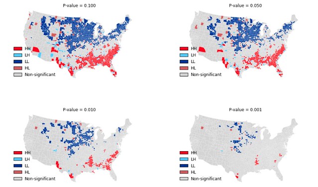
Above: Local Indicators of Spatial Association for Homicide Rates in US Counties 1990.
PySAL modules
- pysal.cg Computational geometry
- pysal.contrib Contributed modules
- pysal.core Core data structures and IO
- pysal.esda Exploratory spatial data analysis
- pysal.examples Data sets
- pysal.inequality Spatial inequality analysis
- pysal.network Spatial analysis on networks
- pysal.region Spatially constrained clustering
- pysal.spatial_dynamics Spatial dynamics
- pysal.spreg Spatial econometrics and diagnostics
- pysal.weights Spatial weights
Installation
PySAL can be installed using pip:
$ pip install pysal
PySAL is also available through Anaconda and Enthought Canopy.
Documentation
For help on using PySAL, check out the following resources:
Development
PySAL development is hosted on github.
Discussions of development occurs on the developer list as well as gitter.
Getting Involved
If you are interested in contributing to PySAL please see our development guidelines.
Bug reports
To search for or report bugs, please see PySAL's issues.
License information
See the file "LICENSE.txt" for information on the history of this
software, terms & conditions for usage, and a DISCLAIMER OF ALL
WARRANTIES.
pysal1.12.0
PySAL 1.12.0
Enhancements
- Numerically roubst centroid computation (possibly resolves #767)
- Moran plot function
- Bugfix of Distance Band Weights where named weights failed because indexing was not label-based
- GSOC weights
- from_iterable/array: weights from any geo-interfaced iterable collection
- from_shapefile: supersedes weights.*_from_shapefile
- from_dataframe: weights from any dataframe-like with column with geometric elements
- from_? others
- incorporated @jlaura's optimized contiguity builder
- Geotable module - extending the shapely extension to apply tabularly, and add some adapters between geopandas and pysal+pandas
- GSOC esda
- all methods now take series/frames natively
- by_col method for bulk computation over a specific dataframe
- to_df for file handles with tabular dimensions
- .make partial application for classifiers
- Numba autojit
- Soft dependency testing for pysal+
- sparse distance band weights code
- Network docfixes
- GSOC spint
- spatial interaction OD weights
-vector-based Moran's I - sparse generalized linear modeling (GLM) module
- unconstrained, production-constrained, attraction-constrained, and doubly-constrained gravity-type spatial interaction models (calibrated using Poisson GLM)
- Tests for overdispersion of Poisson GLM
- spatial interaction OD weights
This is a rolling release consisting of enhancements, bug fixes, and documentation updates including 277 commits, 33 closed pull requests and 67 issues since the last release.
Python Spatial Analysis Library
PySAL is an open source cross-platform library of spatial analysis functions written in Python. It is intended to support the development of high level applications for spatial analysis.
Above: Local Indicators of Spatial Association for Homicide Rates in US Counties 1990.
PySAL modules
- pysal.cg Computational geometry
- pysal.contrib Contributed modules
- pysal.core Core data structures and IO
- pysal.esda Exploratory spatial data analysis
- pysal.examples Data sets
- pysal.inequality Spatial inequality analysis
- pysal.network Spatial analysis on networks
- pysal.region Spatially constrained clustering
- pysal.spatial_dynamics Spatial dynamics
- pysal.spreg Spatial econometrics and diagnostics
- pysal.weights Spatial weights
Installation
PySAL can be installed using pip:
$ pip install pysal
PySAL is also available through Anaconda and Enthought Canopy.
Documentation
For help on using PySAL, check out the following resources:
Development
PySAL development is hosted on github.
Discussions of development occurs on the developer list as well as gitter.
Getting Involved
If you are interested in contributing to PySAL please see our development guidelines.
Bug reports
To search for or report bugs, please see PySAL's issues.
License information
See the file "LICENSE.txt" for information on the history of this
software, terms & conditions for usage, and a DISCLAIMER OF ALL
WARRANTIES.
PySAL v.1.11.2
PySAL 1.11.2 is the second rolling release of PySAL following twelve previous time-specified releases.
Enhancements
This is primarily a maintenance release consisting of bug fixes and documentation updates including 35 commits and the closing of 14 issues since the last release.
Python Spatial Analysis Library
PySAL is an open source cross-platform library of spatial analysis functions written in Python. It is intended to support the development of high level applications for spatial analysis.
Above: Local Indicators of Spatial Association for Homicide Rates in US Counties 1990.
PySAL modules
- pysal.cg Computational geometry
- pysal.contrib Contributed modules
- pysal.core Core data structures and IO
- pysal.esda Exploratory spatial data analysis
- pysal.examples Data sets
- pysal.inequality Spatial inequality analysis
- pysal.network Spatial analysis on networks
- pysal.region Spatially constrained clustering
- pysal.spatial_dynamics Spatial dynamics
- pysal.spreg Spatial econometrics and diagnostics
- pysal.weights Spatial weights
Installation
PySAL can be installed using pip:
$ pip install pysal
PySAL is also available through Anaconda and Enthought Canopy.
Documentation
For help on using PySAL, check out the following resources:
Development
PySAL development is hosted on github.
Discussions of development occurs on the developer list as well as gitter.
Getting Involved
If you are interested in contributing to PySAL please see our development guidelines.
Bug reports
To search for or report bugs, please see PySAL's issues.
License information
See the file "LICENSE.txt" for information on the history of this
software, terms & conditions for usage, and a DISCLAIMER OF ALL
WARRANTIES.
PySAL v1.11.1
PySAL 1.11.1, is the first rolling release of PySAL following twelve previous time-specified releases.
Enhancements
- Enhanced dynamic map classification system
- Well Known Binary support
- Spatial lag for categorical variables
- Unpinning from SciPy 0.16
Among the 66 commits and bug fixes since the last release since the last release.
Python Spatial Analysis Library
PySAL is an open source cross-platform library of spatial analysis functions written in Python. It is intended to support the development of high level applications for spatial analysis.
Above: Local Indicators of Spatial Association for Homicide Rates in US Counties 1990.
PySAL modules
- pysal.cg Computational geometry
- pysal.contrib Contributed modules
- pysal.core Core data structures and IO
- pysal.esda Exploratory spatial data analysis
- pysal.examples Data sets
- pysal.inequality Spatial inequality analysis
- pysal.network Spatial analysis on networks
- pysal.region Spatially constrained clustering
- pysal.spatial_dynamics Spatial dynamics
- pysal.spreg Spatial econometrics and diagnostics
- pysal.weights Spatial weights
Installation
PySAL can be installed using pip:
$ pip install pysal
PySAL is also available through Anaconda and Enthought Canopy.
Documentation
For help on using PySAL, check out the following resources:
Development
PySAL development is hosted on github.
Discussions of development occurs on the developer list as well as gitter.
Getting Involved
If you are interested in contributing to PySAL please see our development guidelines.
Bug reports
To search for or report bugs, please see PySAL's issues.
License information
See the file "LICENSE.txt" for information on the history of this
software, terms & conditions for usage, and a DISCLAIMER OF ALL
WARRANTIES.
PySAL v1.11
PySAL 1.11, the twelfth official release of PySAL, brings the following key enhancements:
Python 3 Support
PySAL now supports Python 3.4+ in addition to Python 2.7.
Enhancements
- Bivariate Local Moran class to compute local bivariate spatial correlations (
esda.Local_Moran_BV) by_col_arrayto extract an array of attributes from file handlers in a more concise way.- Seemingly Unrelated Regression with test for spatial error autocorrelation and coefficient homogeneity, LR and LM test on off-diagonal elements (
spreg.SUR) - Three-Stage Least-Squares Regression with test for coefficient homogeneity (
spreg.ThreeSLS) - Spatial lag SUR using Three-Stage Least-Squares, with test on coefficient homogeneity and joint significance of spatial autocorrelation (
spreg.SURlagIV) - Spatial error SUR using ML w/ LR test on spatial error paramter, off diagonal elements, and coefficient homogeneity; as well as optional asymptotic variance and tests on the spatial error parameter, homogeneity, and joint significance tests (
spreg.SURerrorML) - New Maximum Likelihood estimation options using sparse LU decomposition (
spreg.MLerror) - Optional, soft-dependency Pandas wrappers around PySAL IO (
pdio,contrib.pdutilities) - Optional, soft-dependency single-class Patsy/Pandas wrapper for parametric models in PySAL (
contrib.handler) - Spatial Interaction Module, with frameworks for Unconstrained, Origin-Constrained, Destination-Constrained, and Doubly-Constrained Spatial Interaction models (requires Pandas) (
contrib.spint)
Among the 216 commits and bug fixes since the last release, 6 months ago.
Python Spatial Analysis Library
PySAL is an open source cross-platform library of spatial analysis functions written in Python. It is intended to support the development of high level applications for spatial analysis.
Above: Local Indicators of Spatial Association for Homicide Rates in US Counties 1990.
PySAL modules
- pysal.cg Computational geometry
- pysal.contrib Contributed modules
- pysal.core Core data structures and IO
- pysal.esda Exploratory spatial data analysis
- pysal.examples Data sets
- pysal.inequality Spatial inequality analysis
- pysal.network Spatial analysis on networks
- pysal.region Spatially constrained clustering
- pysal.spatial_dynamics Spatial dynamics
- pysal.spreg Spatial econometrics and diagnostics
- pysal.weights Spatial weights
Installation
PySAL can be installed using pip:
$ pip install pysal
PySAL is also available through Anaconda and Enthought Canopy.
Documentation
For help on using PySAL, check out the following resources:
Development
PySAL development is hosted on github.
Discussions of development occurs on the developer list as well as gitter.
Getting Involved
If you are interested in contributing to PySAL please see our development guidelines.
Bug reports
To search for or report bugs, please see PySAL's issues.
License information
See the file "LICENSE.txt" for information on the history of this
software, terms & conditions for usage, and a DISCLAIMER OF ALL
WARRANTIES.